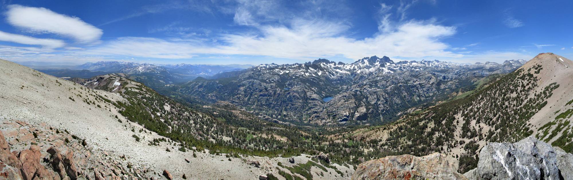
Minarets Region Panorama from Two Teats Detail - Sierra
Panorama from Two Teats on the San Joaquin Mountain ridge looking over the Minarets and the San Joaquin Middle Fork. Left to right is the San Joaquin ridge running SE to mammoth Mtn. Across the Middle Fork San Joaquin River valley left to right is tiny Gladys lake barely visible, then Rosalie Lake, then low, large, and prominent at center is Shadow Lake, then barely visible much farther back up Shadow Creek is Ediza Lake, then higher, closer, but small and also barely visible are Emily, Clarice, and Altha Lakes, with a tiny sliver of huge Garnet lake visible far back behind and between them. Over the next ridge right is huge Thousand Island Lake, slightly more visible but farther away. At far right is San Joaquin Mountain. Left to right behind the lakes are the jagged Minarets on the horizon.Center right, highest and largest at the N end of the Minarets are Mt Ritter left and Banner Peak at right. Mt Lyell then Mt McClure are three close points on horizon center right, and Donahue Peak is the ridged blocky mass much farther right, with Donahue Pass just 2 saddles back left. The John Muir Trail runs SE, exiting Yosemite over Donahue Pass and passing by or very near all the noted lakes before dipping down into the valley just right of mammoth Mtn and then back up through the left tip of the bright green strip where the 1992 Rainbow Fire occurred. In view foreground are the River and High Trails, two alternate trails over this stretch running along the river and halfway up the face of the San Joaquin ridge respectively. California, Sierra Nevada Mountains, Ansel Adams Wilderness, Two Teats. Off the John Muir Trail near Mile 044.